

Topography Lite app for iPhone and iPad
Developer: Georgios Graikousis
First release : 23 Aug 2013
App size: 26.8 Mb
The application is very useful to Civil Engineers, Architects, Surveyors, and those interested in measuring a surface area or converting its coordinates to UTM EGSA87.
This tool enables users to:
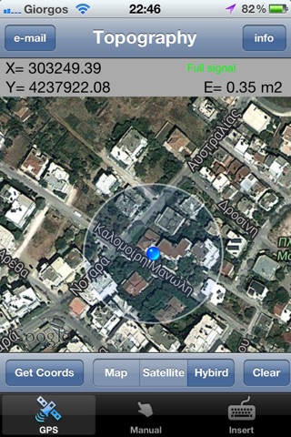
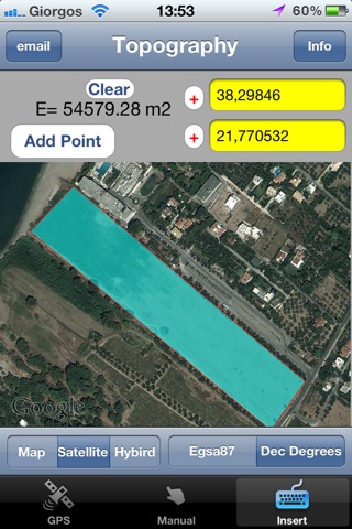
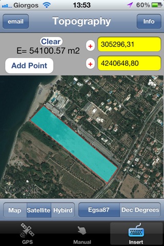
1. Convert the coordinates (x,y) to UTM EGSA87 Datum
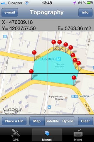
2. Calculate the area of a polygon in square meters (m2)
3. Send the above measurements by e-mail in [dxf] file format. The dxf file can be opened in a MAC or a PC by any drawing application like Autocad.
4. Send measurements by e-mail in [kml] file format. The kml file can be opened in a MAC or a PC or iPhone by GoogleEarth application.
5. Send measurements by e-mail in [TXT] file format. The text file contains coordinates either in EGSA87 Datum or Latitude and Longitude in decimal degrees.
The measurements mentioned above can be provided not only by placing the iPhone in each border of a surface area, but also from distance (when users are on their bed or their sofa). Users may also have their final measurements by entering the coordinates either in EGSA87 Datum or Latitude and Longitude in decimal degrees.
*********Caution:
The Free Version of the program has the additional alteration of EGSA87 coordination by 20% and reduce the measured points.
For accurate results buy the full version !
----------------------------------------------------------------------------------
Η εφαρμογή είναι πολύ χρήσιμη για Πολιτικούς Μηχανικούς , Αρχιτέκτονες , τοπογράφους , και σε όσους ενδιαφέρονται για τη μέτρηση μιας επιφάνειας (γεωτεμαχίου, οικοπέδου κτλ) ή για την μετατροπή των συντεταγμένων της σε UTM ΕΓΣΑ87.
Αυτή η εφαρμογή επιτρέπει στους χρήστες να :
1. Να μετατρέψουν τις συντεταγμένες ( x , y ) στο UTM ΕΓΣΑ87 Datum
2. Να υπολογίσουν το εμβαδόν ενός πολυγώνου σε τετραγωνικά μέτρα (m2)
3. Να στείλουν τις παραπάνω μετρήσεις μέσω e-mail σε μορφή αρχείου [dxf]. Το αρχείο DXF μπορεί να ανοίξει σε MAC ή PC από οποιαδήποτε cad εφαρμογή όπως το Autocad.
4. Να στείλουν τις παραπάνω μετρήσεις μέσω σε e-mail σε μορφή αρχείου [ΚΜL]. Το αρχείο KML μπορεί να ανοίξει σε MAC ή PC ή στο iPhone από την εφαρμογή GoogleEarth.
Οι μετρήσεις που αναφέρονται παραπάνω μπορεί να προέρχονται όχι μόνο από τη τοποθέτηση του iPhone σε κάθε κορυφή της επιφάνειας που θέλουμε να μετρήσουμε, αλλά και από απόσταση, βρίσκοντας την επιφάνεια που μας ενδιαφέρει από τον χάρτη της εφαρμογής μας και επιλέγοντας τις κορυφές της. Οι χρήστες μπορούν επίσης να έχουν τελικές μετρήσεις τους, εισάγοντας τις συντεταγμένες είτε σε ΕΓΣΑ87 Datum ή το γεωγραφικό πλάτος και το γεωγραφικό μήκος σε δεκαδικούς βαθμούς
*********Προσοχή:
Η Free Version του προγράμματος έχει επιπρόσθετη αλλoίωση των συντεραγμένων ΕΓΣΑ87 κατα 20% καθώς και περιορισμό μετρούμενων σημείων.
Για ακριβή αποτελέσματα αγοράστε την πλήρη έκδοση !
Latest reviews of Topography Lite app for iPhone and iPad
It may be a great app, but you cant see it behind the ads. The menu icons overlap each other so you never know what youre selecting. Has potential, but I wont pay for something unless it actually works
This app is hidden behind advertisements. The only thing it would be good for is measuring the area of property with known boundaries...it is not a GPS (and doesnt claim to be).
I could never get it to work. The ads cover everything, so I couldnt even add one marker. Totally deleting
Ads block important parts of the screen and cant find the button to drop the pin, which is necessary.